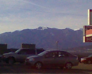
So your on I-25 Southbound, in Colorado.
You take an off ramp in the little town of Apache Colorado. You look West by Southwest, and you'll see the other side of Cuerna Verde, from where I live. If you drew a straight line on a map, from here to where the very tallest peak is on the mountain in the foreground... You'll run right into where I live on the other side.
37 50' 13.23"N, 105 06' 10.09"W
Type those figures in and hit search...And BOOM! Your looking down my chimney.
Before I head back up on the 30th, I'll be posting some pictures of the land where I live. You'll get a grand tour.
So keep checking back till the New Year begins. You'll never know what I'll be up to next?
Be well all,


1 comment:
Dugsy here. Wow, I Googled you and I Am amazed at what I saw.http://maps.google.com/maps?hl=en&q=37+50%27+13.23%22N,+105+06%27+10.09%22W&sourceid=navclient-ff&rlz=1B3GGGL_enUS329US329&um=1&ie=UTF-8&hq=&hnear=%2B37%C2%B0+50%27+13.23%22,+-105%C2%B0+6%27+10.09%22&gl=us&ei=XpUzS_8PweWUB6Pi2aUH&sa=X&oi=geocode_result&ct=title&resnum=1&ved=0CAgQ8gEwAA
Post a Comment